1) leveling
[英]['levəliŋ] [美]['lɛvəlɪŋ]

水准测量
1.
Substitute of the leveling measurement of crossing rivers with EDM triangle elevation;
用EDM三角高程代替跨河水准测量
2.
Digital Leveling and Building GIS Data Management System;
数字化水准测量及其GIS数据管理系统的建立
3.
Variation Characteristics of Leveling Data of Datong Central Seismological Observatory of Shanxi;
山西大同中心地震台水准测量数据变化特征
2) level survey
水准测量
1.
Determination of level survey admissible error;
水准测量允许误差的确定
2.
The integrative system development on indoor and outdoor works base on PDA level survey;
水准测量内外业PDA一体化系统开发
3.
By restricting side length and vertical angle of observing sides, the level survey can be replaced by the triangle elevation method so that measuring accuracy can be increased, the labor strength be reduced and the working time be saved.
通过限制观测边的边长、垂直角的角度,可以用水准式三角高程测量的方法代替三四等水准测量。
3) leveling survey
水准测量
1.
Accurate analysis of total station instrument to replace leveling survey;
全站仪代替水准测量精度分析
2.
In this paper,the theories,techniques,methodologies,and results of monitoring primary fractures connecting to the injection well in Anpeng Alkali Mine are presented, which combines micro-seismic monitoring with leveling survey techniques.
介绍了在桐柏安棚碱矿,用微地震监测结合水准测量监测与注水井连通的原生裂隙带的理论、技术、方法和监测结果,并据此部署开采井位,把采液井打在与注水井连通的裂隙带上,实现了2条注、采井1 000 m井下裂隙带连通,使安棚碱矿可以连续注水、采出碱液,从而获得较高的生产水平和经济效益。
3.
According to Tongliao power plant water source engineering,it particular discuss basis theory and means of combine of GPS and leveling survey,availability results is obtained.
文章结合通辽电厂水源工程,详细论述了GPS和水准测量相结合的基本原理及工作方法,并得出了有益的结论,对今后类似的工程具有一定的借鉴作用。
4) leveling surveying
水准测量
1.
It is presented that the conclusion that total station apparatus triangulated height measurement cannot fully replace leveling surveying at every aspect through detailed analysis and the comparison between the errors of triangulated height measurement and those of leveling surveying, thus provides a reference for the method selection.
本文分析和对比了三角高程测量误差与水准测量误差,得出全站仪三角高程测量不能普遍代替水准测量的结论,给高程测量方法的选择提供了参考根据。
2.
In view of the above-mentioned facts,based on a vast amount of GPS surveying data and leveling surveying data,the law of variations of GPS height anomaly of the P.
鉴于上述原因,笔者与科研组以大量的GPS测量成果和水准测量成果为依据,对我国境内GPS高程异常的变化规律进行了较为系统的整体性分析与研究,初步总结出了我国境内GPS高程异常的变化规律,借助计算机建模技术、通过大量的演算,给出了我国境内GPS高程异常的初步数学模型,为相关领域的研究工作提供了一个参考依据。
3.
0 from Microsoft Company in the leveling surveying to reduce the workload on the field.
0在编写水准测量程序中的实践方法。
5) levelling
['levəliŋ]
水准测量
1.
This paper chiefly introduces the author s development thought of the research on levelling electronic data recording system by application of SHARP PC-E500 computer.
详细介绍了利用SHARPPC -E5 0 0型掌上电脑开发水准测量野外电子记录软件的研制思路 ,并介绍了此软件的功能。
2.
In this paper, the formulas for calculating the astronomical correction in levelling are given.
本文给出了水准测量中天文改正的计算公式,讨论了所给公式的精度,认为可满足精密水准测量的精度要求。
补充资料:水准测量
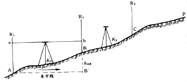
| 水准测量 leveling 依据几何原理用水准仪和水准标尺测定地面两点间高差的方法。高程测量的主要方法。用于建立国家水准网和地区高程控制网,监测地壳垂直运动,研究平均海水面变化,以及为地形测图和各种工程建设提供高程控制。 水准测量是用沿水准路线逐点向前推进的方式实施。为了测量地面上A、P两点间高差(见图),先将水准标尺R1竖立在水准点A 上,再将水准标尺R2竖立在一定距离的B点上,在A、B之间安置水准仪。依据水准仪的水平视线,在标尺上分别读数,两标尺读数差就是A、B两点间的高差hAB。第一站测完后,B点上水准标尺R2保持不动,A点的水准标尺R1移至C点,水准仪移至BC的中间,测得B、C两点间高差hBC,如此继续推进至P点,A、P两点间的高差hAP=hAB+hBC+……。
水准测量首先是选定水准路线和埋设水准标石。水准路线应选在坡度小的交通线上,水准点位置应选在能保证标石稳定,长期保存并便于观测的地点。中国国家水准点上的标石分为基岩水准标石、基本水准标石和普通水准标石3种。基岩水准标石埋设在一等水准路线上,大约每隔500千米一座,作为研究地壳垂直运动的依据。基本水准标石埋设在一、二等水准路线上,每隔60千米左右一座,用于长期保存水准测量成果和研究地壳垂直运动。普通水准标石埋设在各等水准路线上,每隔2~6千米一座,直接为地形测图和各种工程建设提供高程控制。 精密水准测量必须用带测微器的精密水准仪和膨胀系数小的因瓦水准标尺,以提高读数精度、削弱温度变化对测量结果的影响。仪器至标尺的距离约在35~60米,且距前后标尺的距离基本相等,同时采用完善的观测程序,以削减水准仪残余的微小倾斜带来的影响和大气折光影响。 水准测量结果须按所采用的高程系统加入必要的改正,以求出精确的高程。 |
说明:补充资料仅用于学习参考,请勿用于其它任何用途。
参考词条