1) erosion model

侵蚀模型
1.
Research to chloride Ion erosion model for prestressed concrete in chloride environment;
氯盐环境条件下预应力混凝土氯离子侵蚀模型研究
2.
Online application of hearth lining erosion model for No 1 BF at Ma'anshan Iron & Steel Co Ltd;
马钢新1号高炉炉缸侵蚀模型的在线应用
2) soil erosion model
土壤侵蚀模型
1.
Regional soil erosion model is a effective tool for regional soil erosion survey and policy-making of soil and water conservation.
区域土壤侵蚀模型是大区域土壤侵蚀普查和水土保持宏观决策的支持工具,土壤侵蚀模型的研发是土壤侵蚀学科的前沿领域。
2.
According to time factor, the development of soil erosion models is divided into three periods on the basis of the characteristics of models.
土壤侵蚀模型是预报水土流失、指导水土保持措施配置、优化水土资源利用的有效工具。
3.
The Limburg Soil Erosion Model (LISEM) is a published example of this language, and it is a physically-based hydrological and soil erosion model on a catchment scale.
本文结合GIS和流域土壤侵蚀模型,对流域单次降雨侵蚀过程进行动态模拟研究。
3) chloride ion erosion model
氯离子侵蚀模型
4) erosion prediction model
侵蚀预报模型
1.
By the research of hillslope erosion prediction model,the knowledge about the process and the mechanism of soil erosion were strengthened,and the arrangement of soil and water conservation practice on hillslope were supported.
坡面侵蚀预报模型的研究可加深对土壤侵蚀过程及其机理的认识,为坡面水土保持措施配置提供科学支持。
5) distributed erosion model
分布式侵蚀模型
6) sediment yield model
侵蚀产沙模型
1.
Integrating geographical information system and sediment yield model in soil and water conservation monitoring using geographical information system,utilizing the functions of GIS in datum government,spatial analysis and visual acquisition,are the heading of sediment yield modeling.
将侵蚀产沙模型和地理信息系统集成起来,将地理信息系统应用于水土保持监测中,充分利用GIS在数据管理、空间分析及可视化方面的功能,是今后侵蚀产沙模型与水土保持监测的发展方向。
2.
Integrating geographical information system and sediment yield model, using the functions of GIS in datum government spatial analysis and visual acquisition, are the heading of sediment yield modeling.
将侵蚀产沙模型和地理信息系统集成起来,充分利用GIS在数据管理、空间分析及可视化方面的功能,是今后侵蚀产沙模型发展的方向。
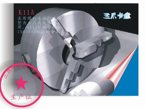
补充资料:AutoCad 教你绘制三爪卡盘模型,借用四视图来建模型
小弟写教程纯粹表达的是建模思路,供初学者参考.任何物体的建摸都需要思路,只有思路多,模型也就水到渠成.ok废话就不说了.建议使用1024X768分辨率
开始
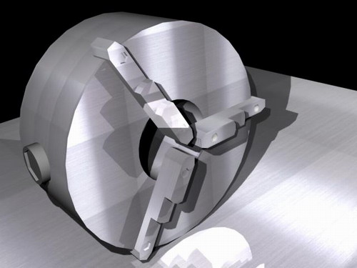
先看下最终效果
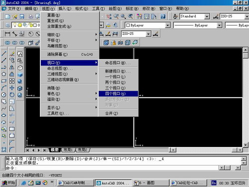
第一步,如图所示将窗口分为四个视图
第二步,依次选择每个窗口,在分别输入各自己的视图
第三步,建立ucs重新建立世界坐标体系,捕捉三点来确定各自的ucs如图

第四步,初步大致建立基本模型.可以在主视图建立两个不同的圆,在用ext拉升,在用差集运算.如图:
第五步:关键一步,在此的我思路是.先画出卡爪的基本投影,在把他进行面域,在进行拉升高度分别是10,20,30曾t形状.如图:
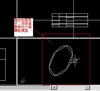
第六步:画出螺栓的初步形状.如图
第七步:利用ext拉升圆,在拉升内六边形.注意拉升六边行时方向与拉升圆的方向是相反的.
之后在利用差集运算
第八步:将所得内螺栓模型分别复制到卡爪上,在利用三个视图调到与卡爪的中心对称.效果如图红色的是螺栓,最后是差集
第九步:阵列
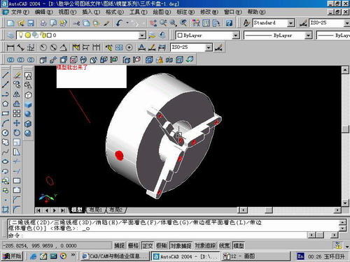
第10步.模型就完成了
来一张利用矢量处理的图片
说明:补充资料仅用于学习参考,请勿用于其它任何用途。
参考词条