1) trigonometric leveling method

三角高程测量法
1.
On new trigonometric leveling method;
新三角高程测量法的探讨
2) Middle method trigonometric leveling
中间法三角高程测量
3) trigonometric leveling
三角高程测量
1.
Precise analysis for EDM trigonometric leveling;
EDM三角高程测量精度分析
2.
Research on the Atmospheric Research Correction in Trigonometric Leveling;
三角高程测量中大气折光改正的教学研究
3.
The selection of station position in short distance trigonometric leveling;
短距离三角高程测量中测站位置的选择
4) EDM trigonometric leveling
EDM三角高程测量
1.
A practicable method of correction for atmospheric refraction in precise EDM trigonometric leveling;
精密EDM三角高程测量中的折光改正实用方法
2.
Through to EDM trigonometric leveling basic principle analysis,Determination measuring origin,And formulates the corresponding quality control measure in actual process,Guaranteed EDM trigonometric leveling satisfies the bridge building-measuring accuracy request,And closes the NANJING Dashengguan bridge as the example.
通过对EDM三角高程测量基本原理的分析,确定测量误差的主要来源,并在施测过程中制定相应的质量控制措施,保证EDM三角高程测量满足桥梁工程测量精度要求,并以南京大胜关长江大桥为例进行说明。
3.
On the basis of the traditional inversion method and the theoretical calculation model of atmospheric vertical refraction coefficient in lowest troposphere, a new inversion method for calculating the refraction coefficients by use of the results of the direct and reversed EDM trigonometric leveling is put forward.
以近地层大气垂直折光系数的传统反演方法和理论计算模型为基础,提出了一种可以直接利用对向EDM三角高程测量结果计算往测与返测折光系数的新反演方法。
5) triangulated height surveying
三角高程测量
1.
The principle of equal-distance and equal-height electromagnetic distance measurement for triangulated height surveying is introduced in this paper.
介绍了等距等高电磁波测距三角高程测量的原理,详细深入地分析了这种高程测量方法的精度,通过计算和作图表示,可直观地反映在不同条件下的精度变化情况,讨论了代替国家等级水准测量的范围和条件,可供生产实际和进一步研究参考。
6) Trigonometric Leveling Method of Distance Measuring
测距三角高程法
补充资料:三角高程测量
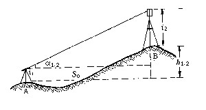
| 三角高程测量 trigonometric leveling 通过观测两点间的水平距离和天顶距(或高度角)求定两点间高差的方法。它观测方法简单,不受地形条件限制,是测定大地控制点高程的基本方法。 三角高程测量的基本原理如图,A、B为地面上两点,自A点观测B点的竖直角为α1.2,S0为两点间水平距离,i1为A点仪器高,i2为B点觇标高,则A、B两点间高差为 h1.2=S0tga1.2+i1-i2
上式是假设地球表面为一平面,观测视线为直线条件推导出来的。在大地测量中,因边长较长,必须顾及地球弯曲差和大气垂直折光的影响。 为了提高三角高程测量的精度,通常采取对向观测竖直角,推求两点间高差,以减弱大气垂直折光的影响。 |
说明:补充资料仅用于学习参考,请勿用于其它任何用途。
参考词条