1) tidal river model

潮汐河工模型
1.
Research on roughness of quincunx-pasted triangle blocks and its application in tidal river model;
潮汐河工模型三角块梅花形加糙试验研究及其应用
2) tide model
潮汐模型
1.
2 and the tide model established by authors respectively.
2和T/P反演的海潮模型改正下的海面高时间序列,通过海面高变化曲线及功率谱的比较确定了利用测高数据发现的海平面季节内变化主要是潮汐模型误差的贡献。
2.
A regional tide model around China(2°N~41°N,99°E~132°E) with a spatial resolution of 5′ has been developed.
利用POM海洋数值模式建立了中国近海(2°N~41°N,99°E~132°E)分辨率为5′×5′的潮汐模型,模式采用b lend ing同化法同化了由10年TOPEX/Pose idon测高数据反演的潮汐参数与沿岸52个验潮站观测。
3) tidal model
潮汐模型
1.
Optimization inversion method for tidal model under open boundary condition:A case study of K_1 constituent amplitude
海域潮汐模型开边界反演优化方法初探——以K_1分潮振幅为例
2.
The advances in coastline extraction based on remote sensing was emphasized,the method in coastline extraction based on the DEM of the intertidal zone and tidal model was proposed,the advantage and disadvantage was analyzed,and the future research orientation was forecasted based on its existent insufficiency in brief.
重点介绍了基于遥感影像提取瞬时水边线,通过潮位校正进而提取海岸线的研究进展,提出了基于潮间带DEM和潮汐模型的海岸线提取方法,分析了各种提取方法的优缺点,并就其存在的不足展望了今后的研究方向。
4) Progressive tidal estuary
淤进型潮汐河口
5) tidal estuary
潮汐河口
1.
Numerical simulation of regulation for tidal estuary inlet;
潮汐河口汊道治理的数值模拟
2.
Numerical simulation of flood on movable bed of a tidal estuary;
潮汐河口动床洪水的数值模拟
3.
Effects of multi-bridge piers on flooding at tidal estuary;
潮汐河口多座桥梁行洪影响的分析
6) tidal river networks
潮汐河网
1.
Development of environmental decision support system for tidal river networks and its application to the Pearl River Delta;
潮汐河网区环境管理决策支持系统开发与应用研究
2.
In recent years, prompted by the urgent need of water pollution control, scientists and engineers on the Pearl River Delta have developed a series of flexible, accurate, and easy to use mathematical models especially suitable for tidal river networks; at the same time many new concepts and new techniques with academic as well as practical values have been advanced.
对珠江三角洲潮汐河网水环境数学模型研究进行了系统的总结。
3.
EDSS is a comprehensive software system for water quality management in tidal river networks in general and for the Pearl River Delta in specific.
EDSS(Environmental Decision Support System)是一个适用于潮汐河网地区水环境管理和决策的软件系统 ,其主要功能是协助政府部门进行有效和科学的水环境管理。
补充资料:AutoCad 教你绘制三爪卡盘模型,借用四视图来建模型
小弟写教程纯粹表达的是建模思路,供初学者参考.任何物体的建摸都需要思路,只有思路多,模型也就水到渠成.ok废话就不说了.建议使用1024X768分辨率
开始
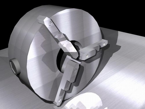
先看下最终效果
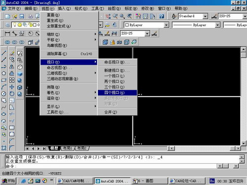
第一步,如图所示将窗口分为四个视图
第二步,依次选择每个窗口,在分别输入各自己的视图
第三步,建立ucs重新建立世界坐标体系,捕捉三点来确定各自的ucs如图

第四步,初步大致建立基本模型.可以在主视图建立两个不同的圆,在用ext拉升,在用差集运算.如图:
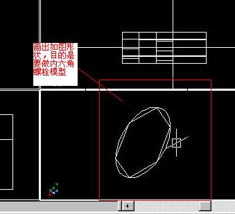
第五步:关键一步,在此的我思路是.先画出卡爪的基本投影,在把他进行面域,在进行拉升高度分别是10,20,30曾t形状.如图:
第六步:画出螺栓的初步形状.如图
第七步:利用ext拉升圆,在拉升内六边形.注意拉升六边行时方向与拉升圆的方向是相反的.
之后在利用差集运算
第八步:将所得内螺栓模型分别复制到卡爪上,在利用三个视图调到与卡爪的中心对称.效果如图红色的是螺栓,最后是差集
第九步:阵列
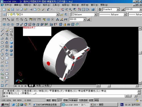
第10步.模型就完成了
来一张利用矢量处理的图片
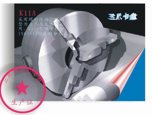
说明:补充资料仅用于学习参考,请勿用于其它任何用途。
参考词条