1) three-dimensional visual techniques

三维可视
1.
By making use of the geography information system(GIS)and three-dimensional visual techniques to the project of Tianjin water transferring from Luanhe River,some reliable foundation and modern instruments can be provided for maintenance management,real-time detection,automatic control,optimizing estimation in water supply,forecast,control and superintending,as well as decision-making support.
论述如何使用地理信息及三维可视技术为引滦入津工程的维护管理、实时检测、自动化监控、输水优化评价、预测、调度指挥以及决策支持提供可靠的依据和现代化手段。
2) 3D visualization
三维可视化
1.
Study on the applying of 3D visualization technique to the construction of informationization in the Xitieshan deposit;
三维可视化技术在锡铁山矿区信息化建设中的应用研究
2.
Research and development of ore body 3D visualization system base on VC~(++) and OpenGL;
基于VC~(++)和OpenGL的矿体三维可视化系统研发
3.
The method of the resolution to fault on 3D visualization continuing interpolation deposit modeling;
基于三维可视化矿床模型的断层整体插值方法
3) Three-dimensional visualization
三维可视化
1.
Research on the mine geology drill data digitize and three-dimensional visualization;
矿山地质钻孔数据数字化三维可视化的研究
2.
The application of three-dimensional visualization technology in exploration and development of Xingou Oilfield;
三维可视化技术在新沟油田勘探开发中的应用
3.
Application of particle system arithmetic in three-dimensional visualization of mine ventilation;
粒子系统算法在矿井巷道风流三维可视化中的应用
4) 3-D visualization
三维可视化
1.
3-D visualization interpretation technique of channels;
三维可视化河道立体解释技术
2.
Particle system-based simulation of flood discharge atomization and 3-D visualization;
泄洪雾化的粒子系统模拟及三维可视化
3.
3-D visualization and analysis for underwater terrain evolution ofthe Pearl River estuary networks in long-term span;
长时间尺度珠江口河网水下地形演变过程三维可视化实现及分析
5) D visualization
三维可视化
1.
3D visualization deposit modeling in the open pit;
露天矿三维可视化矿床地质模型的建立
2.
Most of ore body grade was calculated by hand, but in 3D visualization environment it can be calculated quickly and precisely.
大部分地学中的空间数据插值基于二维空间 ,随着计算机三维可视化工具的出现和功能不断完善 ,三维空间的数据插值成为可能。
3.
With 3D visualization and multi component reservoir parameter inversion as the main measures, full 3D structural interpretation, reservoir prediction and description are performed with a view to the distribution characteristics of the turbidite reservoir of Sha3 central member and its configuration relationship between structures and reservoir forming in Chenjia depression.
针对陈家洼陷沙三中亚段浊积岩储层的分布及其在成藏上与构造的配置关系 ,以三维可视化技术和多元储层参数反演技术为主要手段 ,开展了全三维构造解释和储层预测及描述等系列研究。
6) three dimensional visualization
三维可视化
1.
The development and application of medical image three dimensional visualization;
医学图像三维可视化技术的发展与应用
2.
On the basis of a specific landslide, the in situ monitoring, three dimensional visualization and compressive integrated intelligent analysis methods are introduced.
本文综合课题组在滑坡方面的研究,以具体的滑坡工程为实例,详细介绍了滑坡现场监测、基于GIS的滑坡三维可视化、综合集成智能滑坡分析方法,包括滑坡变形预测的进化支持向量机建模、加固方案优化设计的进化神经网络-数值方法、基于动态聚类的进化神经网络危险性分区、滑体参数反演的进化支持向量机-有限元方法、滑动面搜索的免疫连续蚁群-极限平衡分析、滑动面参教反演的粒子群优化算法等。
3.
Real time three dimensional interactive imitating technology is the key for achieving three dimensional visualization design of road routes.
实时三维交互式仿真技术是实现道路线路三维可视化设计的关键,本文应用约束Delaunay三角剖分原理建立道路三维整体模型,在此基础上,提出并实现了有效的道路三维模型的视相关简化方法,并结合真实感图形绘制技术开发了道路三维场景的实时动态浏览平台。
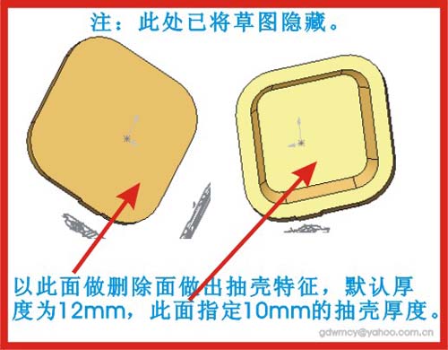
补充资料:AutoCAD二维文件转化成solidworks三维文件
图1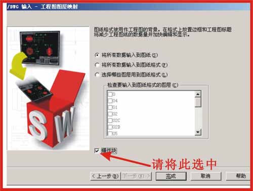
图2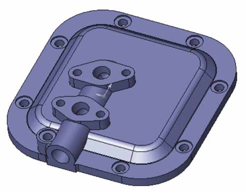
图3
图4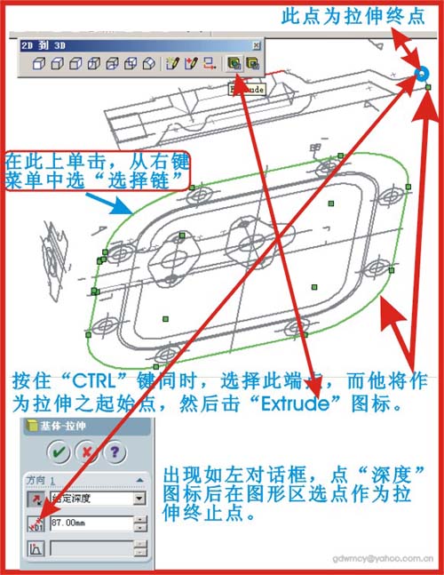
图5
图6
图7
|
说明:补充资料仅用于学习参考,请勿用于其它任何用途。
参考词条