1) typhoon landing position

台风登陆地点
2) landing typhoon
登陆台风
1.
Study on the grey catastrophic forecast of landing typhoon in Zhejiang;
浙江登陆台风的灰色灾变预测研究
2.
The noise removing and velocity ambiguity distinguishing was made in this work for the Doppler radar data collected during August 2005 on landing typhoon Matasa(0509) in Yantai city,Shangdong Province,and the verified result showed that the quality control for this dataset was correct.
反演风场也可以为进一步利用单多普勒雷达探测资料分析和研究登陆台风内部的中尺度结构提供高分辨率的可靠的分析资料。
3.
In order to forecast the occurrence year of a landing typhoon in Zhejiang, a commensurable formula of three elements was used in arrangement and calculation.
为了对浙江登陆台风的发生年份进行预测 ,采用三元可公度式进行排列计算 ,可以得到其后几年内的可公度式 ,并根据可公度式频数的峰值进行判断。
3) Landfalling typhoon
登陆台风
1.
Inter-annual variations and especially,trends of frequency,intensity and location of landfalling typhoons in China are investigated in contrast with typhoons in the Northwestern Pacific based on the data of tropical cyclones in the Northwestern Pacific,landfalling typhoons in China and the global surface temperature from 1949 to 2002.
结果表明:在全球气候变暖背景下,我国登陆台风频数的减少趋势没有西北太平洋台风频数的减少趋势强;登陆台风的平均强度和极端强度均有减弱趋势,极端强度的减弱趋势尤为明显,但其强度弱于西北太平洋台风。
2.
By using GMS-5 IR1 TBB of landfalling typhoon(LT) and hourly rainfall from ground automatic weather stations,a preliminary method of quantitative precipitation estimation(QPE) suitable for LT was found.
利用登陆台风的GMS-5 IR1 TBB资料及地面自动站逐时雨量资料,初步建立了适用于登陆台风的定量降水估计(QPE)方法,基于QPE结果,采用外推法,初步实现了对登陆台风未来0~3 h的短时定量降水预报(QPF)。
4) landfall typhoon
登陆台风
1.
Observational Analysis for a Torrential Rain Caused by a Landfall Typhoon;
邯郸地区一次登陆台风大暴雨过程观测分析
2.
The evolution and structure of two organized meso-α-scale convective systems developed sequentially on the landfall typhoon low during 3-5 August 1996 are simulated successfully using Penn State/NCAR mesoscale model version 5(MM5).
由此根据模式输出结果分析了这两个中尺度对流系统(MCS)的中尺度结构和特点 ,最后给出了登陆台风低压暴雨的MCS结构模型 ;在MCS成熟期 ,低层大尺度的低空急流 (LLJ)中出现中尺度扰动 ,即中尺度低空急流 (mLLJ) ,mLLJ的左前方产生强辐合和上升运动 ,在上升气流的高空出流区域产生中尺度高空急流 (mULJ) ,这种mULJ在常规观测资料中被验证。
3.
The main affecting systems include landfall typhoon,low-level jet stream and west trough.
主要影响系统为登陆台风、西风低槽和低空急流。
6) landfall position
登陆地点
1.
Analysis of the second landfall position of typhoon 0519;
0519号台风“龙王”第二次登陆地点的认知分析
2.
Analysing on the landfall position of typhoon "Sinlaku"(No.0216);
0216号台风“森拉克”登陆地点的探讨
3.
Exploration about landfall position of tropical storm "Morakot"(No.0309);
关于0309号热带风暴“莫拉克”登陆地点的探讨
补充资料:“台风“级弹道导弹核潜艇
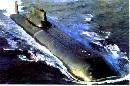
“台风“级弹道导弹核潜艇
该级艇首艇 tk208 于 1990 年在北德文斯克的北方机器厂开始改装 , 于 2002 年 6 月26日改装完毕后下水。
" 台风 " 级弹道导弹核潜艇是迄今为止世界上吨位最大的潜艇。艇体包括 2个独立的直径为 7.2m 的耐压艇体, 外壳是单层自由进水壳体 , 敷有消声瓦, 另外在水平舵和艇艏处还有独立的直径 6m 的耐压舱。沿舷侧处外壳与耐压艇体之间有 1.2m 的间隙 。 " 台风 " 级核潜艇特点是体积巨大, 而且导弹发射管 布置在水平舵之前。如此布置导弹发射管目的就是让艏部区域全部用于布置武器 , 而水平舵之后的区域用于布置反应堆 , 每个耐压艇体中布置一个反应堆。该级艇水平舵的结构被设计成能穿透至少 3m 厚的冰层 ; 其可伸缩的首水平舵、圆形的艇体和水平舵的外型均是按冰下航行的需要设计的。下潜深 度 3 00m 。该级艇的所有鱼雷发射管均是 533m 发射管。
该级艇装备有两套甚低频 / 极低频通信浮标 , 冰下航行用的甚低频导航系统," 活泼泉 " 卫星通信梳杆 ," 鳕鱼眼 " 辐射六分仪和 " 卡莱姆尼 "2 敌我识别器。所有艇都属于俄罗斯北海舰队 , 基地位于立特萨·库巴。 tk17 号艇在 1992 年装填导弹时由于火灾而遭受损坏 , 但目前已修复。还有两艘自1966年以来一直停用 , 美海军同意对这两艘的反应堆退役和肢解艇体提供帮助。
该级艇的人力成本和维护成本都很高。所有艇即使在更换燃料之前不退役 , 也可能会在燃料用尽时退役。
说明:补充资料仅用于学习参考,请勿用于其它任何用途。