2) Taer Power Plant

塔尔电厂
1.
The Estimation of Groundwater Resource in Taer Power Plant;
塔尔电厂地下水资源评价
3) Zhungeer coal
准格尔煤
1.
Study on fusibility of coal ash in blending Shenhua mixed coal and Zhungeer coal
神华混煤与准格尔煤掺烧及其煤灰熔融性研究
2.
To solve these problems,two retrofit schemes,with which relevant pollutant emission standards can be satisfied,are being put forward for ESPs of currently Zhungeer coal-fired power plants.
针对现役燃用准格尔煤电厂的电除尘器,提出了能够满足排放标准的改造方案:在现役电除尘器中,增设"石灰石-石膏"湿法脱硫装置,或采取"电除尘器+烟气调质"方案,同时将原有常规高压电源改成带EPIC-II型电压优化控制器的电源,以便进一步提高电除尘器运行的稳定性和节能效果。
4) Zhungeer county
准格尔旗
1.
Research on Land Use Change and Sustainable Use Model in Zhungeer County;
准格尔旗土地利用变化与持续利用模式研究
2.
Take Zhungeer county as an example, depend on remote sensing images and other data, utilizing GIS software contained ARC/INFO and remote sensing software ERDAS, after disposition, transition of pattern and query, interpretation, the study achieve the soil erosion data of the area.
以内蒙古准格尔旗为例 ,利用 TM图像及相关辅助数据 ,通过 GIS软件 ARC/INFO、遥感软件 ERDAS IMAGINE 8。
3.
Located in the transitional zone from agricultural areas to husbandry areas, Zhungeer county has typical characteristics of fragile ecological situations with serious soil and water loss.
准格尔旗位于我国农牧业交错区,生态环境脆弱,水土流失和土地退化严重。
5) Jungar Banner
准格尔旗
1.
Model of Returning Crop Plots to Forestry and Grassland in Hilly and Gully Area of Jungar Banner, Inner Mongolia;
内蒙古准格尔旗丘陵沟壑区退耕还林(草)模式
2.
Benxi Formation in Duijiugou, Jungar Banner, Inner Mongolia is described and the brachiopod fauna from the formation is carefully analysed.
介绍了内蒙古准格尔旗对臼沟本溪组含腕足动物地层,对该区本溪组腕足动物群的性质特点进行了分析。
6) Jungar Qi
准格尔
1.
Based on the climatic data from 1959 to 2001 and statistical data from 1980 to 2003 in Jungar Qi and the field experiments in different crops types and crop varieties during 2003 and 2004, the climatic condition, the water comsumption, crop yield, quality of the crops were analyzed.
本文以内蒙古准格尔旗为例,对1959~2001年的气象资料和1980~2003年的统计资料进行分析,并于2003~2004年进行不同作物和作物品种的田间试验,在分析作物耗水量、产量、品质的基础上,考虑种植业的经济效益、社会效益和生态效益,建立种植业结构调整的线性规划模型。
补充资料:邦格尔邦格尔山脉
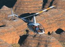
邦格尔邦格尔山脉
位于珀努卢卢国家公园里的邦格尔邦格尔山脉是西澳大利亚洲最具魅力的地质奇观,与乌奴奴(艾雅斯岩)大堡礁等自然奇观并列。这个山脉高出海平面578米,高出平原200~300米,被森林和草地覆盖,还有陡峭的悬崖。
从飞机上看,邦格尔邦格尔山脉交织着橘色和黑色的条纹的蜂窝状的小山,镶嵌在硅土和海藻覆盖的表皮之中,在南部看整个山脉非常清晰。横扫整个山脉,会看到一个隐藏的山川世界,被风之手不停的雕琢在岩石上。邦格尔邦格尔山脉逢雨季的时候植物和动物资源丰富,这些资源被土著人充分利用,直到80年代中期白人才知道这个地方。因此这里有很多土著艺术和土葬遗址。
条纹的蜂窝状的岩石结构,沙石悬崖和邦格尔邦格尔山脉的山顶,都是珀努卢卢国家公园里非常有名的景观。世界遗产协会指出这里重要的土著文化遗迹有20,000年历史。难以置信的是这些山顶、峡谷和雨季的瀑布除了诗人、科学家和土著,直到1982年才为人们所知道。那时候航拍的照片第一次被公开,广泛流传。
说明:补充资料仅用于学习参考,请勿用于其它任何用途。