1) CA-Landslide model

CA-Landslide模型
2) CA model
CA模型
1.
The traditional CA model simulates the complex city system based on the from-bottom-to-top thinking,and has neglected the influence of the macroscopic decision-making to the evolution of the urban morphology.
基于CA模型,从城市规划角度,通过引入控制性详细规划层,将整个城市空间划分为不同组团片区,构建了自下而上和自上而下相结合的城市规划CA模型(UPCA),并以长沙市为例进行实证研究。
2.
Using the advantage of GIS in spatial analysis and the CA model in imitating the complex progress to integrate them,CA model was established to imitate and forecast the interaction of water and rock mass, define the area of environmental effects and get the essential regularities to forecast the environmental effec.
利用GIS空间分析与CA模型模拟复杂演化过程的优势,将两者集成来模拟和预测库岸水岩的相互作用,建立相应的模型来揭示其本质规律,圈定影响区域,为其导致的环境效应做出相应的预测。
3.
After the influence factors and limiting factors were confirmed,simulation and prediction of urban expansion for the study area were made based on the CA model theory.
利用长时间序列高分辨率LandsatTM影像,对吉隆坡及其周边地区城市扩展模式特征及驱动机制进行了分析,确定了其影响因子和限制因素,并基于CA模型原理对该研究区的城市扩展进行了模拟与预测。
3) BPNN-CA model
BPNN-CA模型
4) CA-AR model
CA-AR模型
1.
Application of CA-AR model in simulation of attribute changes for population space field;
CA-AR模型在人口空间场属性变化模拟中的应用
2.
In order to forecast the trend of continual state attribute in the geographic spatial field, CA-AR model was set up to simulate the dynamic evolution of continual state spatial field based on CA and AR method.
为了预测连续状态属性在地理空间场中的变化趋势,本文在CA和AR方法的基础上,构建了模拟连续状态空间场动态演化的CA-AR模型。
5) CA-Markov model
CA-Markov模型
1.
Utilizing "3S" technology and CA-Markov model in IDRISI software,taking year of 2005 as initial time,the writers carry on analogue forecasting of year for 2015 land utilization arragement of kizilsu kirgiz Autonomous Prefecture Xinjiang.
利用"3S"技术及IDRISI软件中的CA-Markov模型,以2005年为起始时刻,对新疆克州2015年土地利用格局进行模拟预测。
2.
The dynamic simulation of Xianghai Natural Reserve is made to research the future transition direction of land cover types with the CA-Markov model,the simulation accuracy is more than 74.
论文借助地理信息技术,采用CA-Markov模型,以1988、1996、2003年3个相同时相的TM遥感影像作为数据基础,并结合地形图和相应的交通、气候等数据对向海自然保护区未来的土地覆被类型进行动态模拟和预测。
3.
With the aid of the CA-Markov model,impacts of land use on the wetland landscape pattern of the Naoli River Watershed was analyzed.
采用CA-Markov模型方法,研究挠力河流域不同时段土地利用对湿地景观格局干扰强度的差异性。
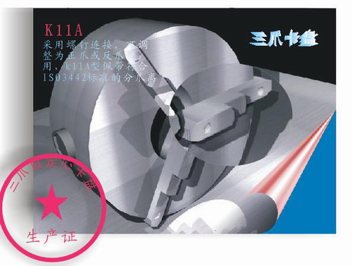
补充资料:AutoCad 教你绘制三爪卡盘模型,借用四视图来建模型
小弟写教程纯粹表达的是建模思路,供初学者参考.任何物体的建摸都需要思路,只有思路多,模型也就水到渠成.ok废话就不说了.建议使用1024X768分辨率
开始
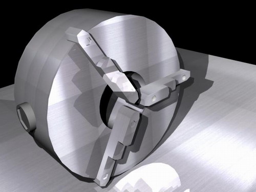
先看下最终效果
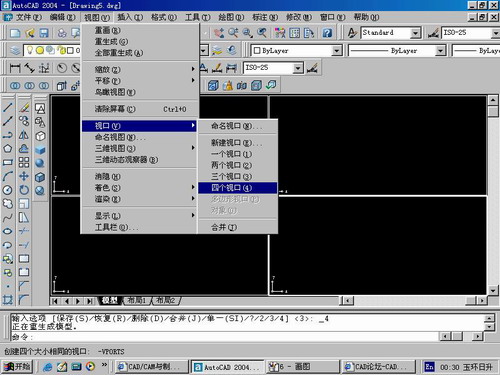
第一步,如图所示将窗口分为四个视图
第二步,依次选择每个窗口,在分别输入各自己的视图
第三步,建立ucs重新建立世界坐标体系,捕捉三点来确定各自的ucs如图

第四步,初步大致建立基本模型.可以在主视图建立两个不同的圆,在用ext拉升,在用差集运算.如图:
第五步:关键一步,在此的我思路是.先画出卡爪的基本投影,在把他进行面域,在进行拉升高度分别是10,20,30曾t形状.如图:
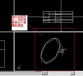
第六步:画出螺栓的初步形状.如图
第七步:利用ext拉升圆,在拉升内六边形.注意拉升六边行时方向与拉升圆的方向是相反的.
之后在利用差集运算
第八步:将所得内螺栓模型分别复制到卡爪上,在利用三个视图调到与卡爪的中心对称.效果如图红色的是螺栓,最后是差集
第九步:阵列
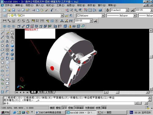
第10步.模型就完成了
来一张利用矢量处理的图片
说明:补充资料仅用于学习参考,请勿用于其它任何用途。
参考词条