1) the Changbai mountains

长白山脉
2) Sobaek Mountains
小白山脉
3) T'aebaek Mountains
太白山脉
4) Changbaishan volcano
长白山火山
1.
Hazards of Changbaishan volcano and its impact on large engineering projects;
长白山火山灾害及其对大型工程建设的影响
2.
Changbaishan Volcano is located on the boundary of China and North Korea,its continuous eruptions occurred from Pliocene to modern time.
长白山火山跨越中朝两国,在我国境内包括天池火山、望天鹅火山、图们江火山和龙岗火山,火山活动从上新世持续到近代,是我国最大的第四纪火山分布区。
3.
It showed that the Changbaishan volcano is entering into a new active stage.
对长白山火山监测站2000-2005年的水化学观测数据进行了对比分析研究,结果表明,自2001年以来各测项观测值包括温泉水水温在逐年增高,表明长白山火山为正进入一个新的活跃阶段。
5) Changbai Mountain
长白山
1.
Seasonal Variation of Total Gaseous Mercury in Changbai Mountain Area;
长白山地区大气气态总汞含量的季节性特征研究
2.
Changbai Mountain Bee Product and Synthetical Exploitation Approach;
长白山蜂产品及其综合开发途径
3.
Current Status and Progress of Industrial Development of Ecological Food in Changbai Mountain Area;
长白山区生态食品产业化开发现状与发展
6) Changbai mountain
长白山区
1.
Analysis of trace elements and vitamins in Esholtzua cltiata(Thunb) Hyland on Changbai mountain region;
长白山区野生香薷中微量元素和维生素的分析
2.
Determination of Trace Elements in Traditional Chinese Medicine from Changbai Mountain by ICP-MS;
长白山区野生、种植贝母和白术中微量元素的ICP-MS对比分析
3.
Study on the Relationship between Transpiration of Carex meyeriana and Environmental Factors in the Changbai Mountain Region;
长白山区乌拉苔草蒸腾规律及环境因子间关系的研究
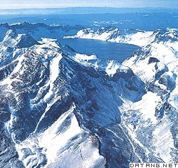
补充资料:长白山脉
| 长白山脉 位于中国吉林省、辽宁省、黑龙江省东部。北起三江平原南侧,南延至辽东半岛与千山相接,包括完达山(831米)、老爷岭(1478米)、张广才岭(1690米)、吉林哈达岭等平行的断块山地。长1300余千米。海拔多在800~1500米 ,以中段长白山最高,向南、北逐渐降低。狭义的长白山指吉林省东部与朝鲜民主主义人民共和国交界的山地。为东北山地最高部分。中国境内的白头峰海拔2691米,由粗面岩组成,夏季白岩裸露,冬季白雪皑皑,终年常白,系多次火山喷发而成。长白山为松花江、图们江、鸭绿江的发源地。森林茂密、垂直分布明显。是中国重要的林区。1961年建立面积21.5万公顷的长白山国家自然保护区。已加入国际人与生物圈计划。
|
说明:补充资料仅用于学习参考,请勿用于其它任何用途。
参考词条