1) Mercator
[mə:'keitɔ:]

墨卡托
1.
We improved arithmetics of Mercator mapping transform and inverse transform.
改进了墨卡托变换与逆变换算法。
2) Mercator sailing method
墨卡托法
3) Gerardus Mercator (1512~1594)
墨卡托,G.
4) Mercator projection
墨卡托投影
1.
By Mercator projection,the geographical coordinates of the ship can be transformed to plane rectangular coordinate,then to the screen coordinate.
通过墨卡托投影,将船舶所处位置地理坐标转换平面坐标,再由平面坐标转换为屏幕坐标,同时将海图按Inmarsat系统作用区域进行划分,推导出每块区域边缘曲线公式,从而可以判断出该船所在的洋区以及与卫星之间的距离,以选择对应卫星进行通信。
2.
In hydrographic sweeping survey,considering that the surveyed route in design project description is a longer route which is composed of two geodetic coordinates,methods of Mercator projection,UTM(Universal Transverse Mercator) projection and Gauss-Kruger projection were adopted to eliminate the direction deviation of sweeping survey,and conform to the conventional way of sweeping survey as well.
在海道扫测工作中,考虑到设计任务书中的扫测航路是由两点大地坐标组成的较长路线,利用墨卡托投影和UTM投影及高斯-克吕格投影方式既能消除扫测航向的偏差,又能符合常规扫测方法。
3.
In order to solve the problem of chart projection transformation among all projections in shiphandling simulator,using the theory of power series spreading out and the method of trigonometric power series calculating back, a direct and reverse solving algorithm models of meridian arc length, and Gauss projection and Mercator projection transforming algorithm are introduced in this paper.
为了解决船舶操纵模拟器中不同投影方式海图的投影变换问题 ,应用幂级数展开理论和三角级数回求方法 ,给出了子午线弧长、等量纬度的直接正反解算法模型及高斯投影与墨卡托投影的相互转化算法 。
6) Mercator chart
墨卡托海图
1.
Method of coordination transformation between Mercator chart and Gauss kilometre map;
墨卡托海图与高斯公里网图坐标转换方法
2.
This paper analyzes the problem of Sun s high altitude position circle on Mercator chart, curvature radius and centre,thus coming to the conclusions: (1) The method of plotting position line of Sun s high altitude may extend to h ⊙≥87°36′.
分析了太阳特大高度的船位圆在墨卡托海图上的投影、曲率半径和曲率中心,并且由此得到如下结论。
3.
In this paper the author examined and argued about the errors in translations of meridianal parts, MP, into Chinese, according to the guiding rules for translations and definitions in navigation, and named the MP in chinese Wei Ju, which means the distance between the equator and a given parallel on a Mercator chart.
本文根据国家自然科学名词审定委员会所规定的译名的基本原则和航海学中的定义,讨论了MP汉语译名中的错误,并提出正确的命名“纬距”及其涵义(在墨卡托海图上,某地纬圈至赤道的距离)。
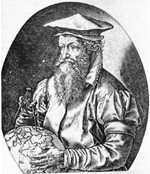
补充资料:墨卡托
| 墨卡托(1512~1594) Mercator,Gerardus 比利时裔德国地图学家。生于比利时鲁贝尔蒙德,卒于德国杜伊斯堡。曾就学于比利时卢万大学。后居德国,被任命为宫廷宇宙学者。一生致力于地理制图,编绘过多种地图,制造过地球仪和天球仪。创用正轴等角圆柱投影(后称墨卡托投影)编制航海图,使航海者可依图直接导航,不需转换罗盘方向;编制了一部包括世界各地区(后经其子续编)的《墨卡托地图集》。并采用古希腊神话中半神半人阿特拉斯(Atlas)的名字命名,从此,这一名称成为地图集的专名。
|
说明:补充资料仅用于学习参考,请勿用于其它任何用途。
参考词条