1) mine surveying instrument

矿山测量仪<测>
2) mine surveying instrument
矿山测量仪器
3) mine surveying
矿山测量
1.
Design and implementation of mine surveying information management system based on B/S structure
基于B/S结构的矿山测量信息管理系统的设计与实现
2.
This paper expounds the surveying principles of GPS (PPK),and probes into the application of GPS (PPK) surveying and positioning in the mine surveying.
简述了GPS(PPK)的测量原理,探讨了差分GPS(PPK)测量定位在矿山测量中的应用。
3.
The basic theory and constitution of GPS-RTK technology was introduced in this paper, generalized the application of GPS-RTK technology in mine surveying, analyzed the applied dominance and advantage of GPS-RTK technology, and gave some valuable opinions for the problems in practical application.
本文简要介绍了GPS-RTK技术基本原理及构成,阐述了GPS-RTK技术在矿山测量中的应用,分析了GPS-RTK技术具体应用中的优势和优点,并就RTK技术在实际应用中遇到的问题提出有益的见解。
4) mining surveying
矿山测量
1.
To counter present technique and application problem of mine surveying,the paper analyzed the challenge and opportunity of mining surveying brought by building up digital mining area and digital mine, and discussed the present countermeasure can be adopted by mining surveying circles, then pointed out that building up digital mine area and digital mine is the sig.
在介绍“数字地球”基本概念及关键技术的基础上 ,总结了“数字地球”提出后在国内矿山测量界引起的反响 。
2.
The advantage of the application of GPS/GLONASS combined positioning in mining surveying is systemically analyzed,and the the key issues of combined positioning should be resolved are discussed.
系统分析GPS/GLONASS组合定位在矿山测量中的优势,论述组合定位需要解决的关键问题,结合具体实例阐述GPS/GLONASS组合定位在矿山测量中的应用。
5) mine survey
矿山测量
1.
This article presents methods of putting independent point to clever use to control secretly for mine survey and methods of correct inspection.
介绍了矿山测量中巧妙利用独立点进行加密控制的方法和正确性的检验方法。
2.
The mine survey maps are devided into three types according to their features , and managed in different methods.
根据矿山测量中不同类型图件的特点,将其分成三类,并采用不同的方式进行管理。
3.
,and Excel application in mine survey work is discussed.
本文简要介绍了利用Excel中的TRUNC,RADIANS,DEGREES函数进行角度单位转换,以水平角度测量、水准测量、导线测量和坐标反算等内业计算为例,探讨Excel在矿山测量工作中的应用。
6) mine survey,mine surveying,mineral survey,mineralogical survey,mining survey
矿山测量<测>
补充资料:长度测量工具:渐开线测量仪
测量渐开线齿形的齿轮测量工具(见长度测量工具)。常见的有单盘式和万能式两种。
单盘渐开线测量仪 採用基圆盘直尺机构﹐以展成法(见齿轮测量)进行测量(图1 单盘式渐开线测量仪 )。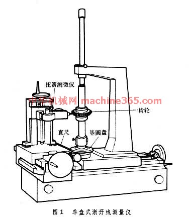 可测齿轮的最大直径一般不大於 600毫米。测量不同直径的齿轮时﹐需要配以相应的基圆盘。它适用於大批量生產中测量5~6级精度的齿轮﹐精度高的可测3~4级精度的齿轮。
万能渐开线测量仪 主要有3种。机械式万能渐开线和螺旋线测量仪(图2 机械式万能渐开线和螺旋线测量仪 )。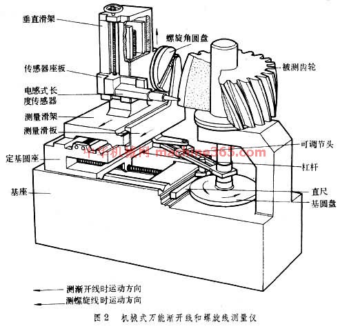 它採用槓桿式基圆可调机构﹐以展成法测量。测量滑架与测量滑板可以固定成一体﹐因此测量滑架移动时﹐通过可调节头﹑槓桿带动直尺使基圆盘和被测齿轮转动。可调节头轴心线和电感式长度传感器测头的刃口位於与被测齿轮基圆相切的同一平面内﹐所以刃口相对於被测齿轮的运动轨跡是渐开线﹐将这一运动轨跡与被测齿形比较﹐齿形误差即由长度传感器转换为电信号﹐并由记录器绘出误差曲线图。利用定基圆座可以按被测齿轮基圆半径确定可调节头轴心线与主轴轴心线间的距离﹐所以不需更换基圆盘即可测量不同直径的齿轮。图2 机械式万能渐开线和螺旋线测量仪 中的测量机构还可测量螺旋线误差。测量前﹐利用光学分度头(图 机械式万能渐开线和螺旋线测量仪 中未表示)调整螺旋角圆盘的直槽的倾斜角﹐使之等於基圆螺旋角﹐并使测量滑架与测量滑板鬆开。当垂直滑架移动时﹐通过螺旋角圆盘﹑测量滑板﹑可调节头﹑槓桿带动直尺使基圆盘和被测齿轮转动来测量螺旋线误差。机械式万能渐开线测量仪可测直径达2000毫米以上的齿轮﹐按被测齿轮直径不同﹐可测4~6级精度的齿轮。採用圆光栅﹑长光栅或激光干涉仪等作为坐标测量系统和电子计算机等作为控制﹑数据处理系统﹐以法线展开角坐标法测量的电子式万能渐开线测量仪。它可测3~5级精度的齿轮。利用直角坐标法测量的上置式万能渐开线测量仪﹐有机械式和电子式两种。前者由人工进行数据处理﹐效率极低﹐精度也不高﹔后者採用两个长光栅测量系统和电子计算机等分别作为直角坐标测量系统和控制﹑数据处理系统﹐测量效率和精度都较高﹐适宜於测量直径1000毫米以上﹑5级精度以上的大齿轮。
单盘渐开线测量仪 採用基圆盘直尺机构﹐以展成法(见齿轮测量)进行测量(图1 单盘式渐开线测量仪 )。
可测齿轮的最大直径一般不大於 600毫米。测量不同直径的齿轮时﹐需要配以相应的基圆盘。它适用於大批量生產中测量5~6级精度的齿轮﹐精度高的可测3~4级精度的齿轮。 万能渐开线测量仪 主要有3种。机械式万能渐开线和螺旋线测量仪(图2 机械式万能渐开线和螺旋线测量仪 )。
它採用槓桿式基圆可调机构﹐以展成法测量。测量滑架与测量滑板可以固定成一体﹐因此测量滑架移动时﹐通过可调节头﹑槓桿带动直尺使基圆盘和被测齿轮转动。可调节头轴心线和电感式长度传感器测头的刃口位於与被测齿轮基圆相切的同一平面内﹐所以刃口相对於被测齿轮的运动轨跡是渐开线﹐将这一运动轨跡与被测齿形比较﹐齿形误差即由长度传感器转换为电信号﹐并由记录器绘出误差曲线图。利用定基圆座可以按被测齿轮基圆半径确定可调节头轴心线与主轴轴心线间的距离﹐所以不需更换基圆盘即可测量不同直径的齿轮。图2 机械式万能渐开线和螺旋线测量仪 中的测量机构还可测量螺旋线误差。测量前﹐利用光学分度头(图 机械式万能渐开线和螺旋线测量仪 中未表示)调整螺旋角圆盘的直槽的倾斜角﹐使之等於基圆螺旋角﹐并使测量滑架与测量滑板鬆开。当垂直滑架移动时﹐通过螺旋角圆盘﹑测量滑板﹑可调节头﹑槓桿带动直尺使基圆盘和被测齿轮转动来测量螺旋线误差。机械式万能渐开线测量仪可测直径达2000毫米以上的齿轮﹐按被测齿轮直径不同﹐可测4~6级精度的齿轮。採用圆光栅﹑长光栅或激光干涉仪等作为坐标测量系统和电子计算机等作为控制﹑数据处理系统﹐以法线展开角坐标法测量的电子式万能渐开线测量仪。它可测3~5级精度的齿轮。利用直角坐标法测量的上置式万能渐开线测量仪﹐有机械式和电子式两种。前者由人工进行数据处理﹐效率极低﹐精度也不高﹔后者採用两个长光栅测量系统和电子计算机等分别作为直角坐标测量系统和控制﹑数据处理系统﹐测量效率和精度都较高﹐适宜於测量直径1000毫米以上﹑5级精度以上的大齿轮。
说明:补充资料仅用于学习参考,请勿用于其它任何用途。
参考词条