2) Tahe

塔河
1.
Design of Forest Resource Management System Based on WEBGIS in Tahe Forestry Bureau;
基于WEBGIS的塔河林业局森林资源管理系统的设计
2.
Geochemistry and source characteristics of early Cretaceous volcanic rocks in Tahe,north Da Hinggan Mountain.;
大兴安岭北段塔河地区早白垩世火山岩地球化学及源区特征
3.
Petrological Characteristics and Tectonic Implications of the Tahe Gabbro in the Northern Part of the Great Xing’an Range;
大兴安岭北段塔河辉长岩的岩石学特征及其构造意义
3) Tahe Oil Field
塔河油田
1.
Main influence factor on water bearing analysis of fracture-karst caved carbonate reservoir of Tahe oil field;
塔河油田缝洞型碳酸盐岩油藏含水变化主要影响因素分析
2.
Development Character & Dominant Factor of Cave-Reservoir in Lower-Middle Ordovician of Ⅷ section in Tahe oil field's;
塔河油田8区中下奥陶统洞穴型储层发育特征及控制因素
3.
High resolution sequence of stratigraphy and sedimentary evolution of middle-upper Trimassic in the 9th Area, Tahe Oil Field;
塔河油田9区三叠系中上统高分辨率层序地层及沉积演化
4) Tahe oilfield
塔河油田
1.
Sedimentary facies division of Yijianfang Formation in the middle Ordovician of the southern Tahe Oilfield;
塔河油田南部中奥陶统一间房组沉积相精细划分
2.
Application of the well test interpretation method for fracture-vug reservoir in Tahe Oilfield;
缝洞型油藏试井解释方法在塔河油田的应用
3.
3D modeling of Ordovician fractured-vug carbonate reservoir,Tahe Oilfield;
塔河油田奥陶系缝洞型碳酸盐岩储集层三维地质建模
5) Tarim River
塔里木河
1.
Influence of Wasteland Development on Tarim River Quality and Primary Countermeasure——A Case Study from Alar Hydrometric Station;
土地开发影响下的内陆河流水质演变研究——以塔里木河干流区上游为例
2.
Effects of Emergent Water Project on vegetation coverage in the lower reaches of Tarim River;
应急输水工程对塔里木河下游地区植被覆盖度的影响
3.
Local Resident's Response to Ecological Water Re-inflowing into Lower Reaches of Tarim River;
当地居民对塔里木河下游应急输水响应分析
6) the Tarim River
塔里木河
1.
Impact-post Assessment of Ecological-based Emergent Water Conveyance Project at Downstream the Tarim River;
塔里木河下游生态应急输水工程影响后评价内容探讨
2.
Water Quality Assessment and Ecological Security Research in Main Stream of the Tarim River;
塔里木河干流水质评价及生态安全性研究
3.
Monitoring and assessment of emergent water transportation and ecological improvement in the lower reaches of the Tarim River;
塔里木河下游应急输水与生态改善监测评估
补充资料:河内
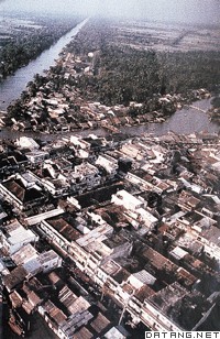
| 河内 Ha Noi 越南首都,经济、文化中心。位于红河三角洲西北部,红河与急流江的汇合处。面积597平方千米。包括郊区在内人口约306万。地处肥沃的冲积平原。年平均气温23.6℃,年降水量约2000毫米,属热带季风气候。有1000年以上的历史,古称龙渊、龙编。1010年李朝在此建都,成为全国的政治、经济中心。16世纪发展为东南亚国际贸易的重要港口。1831年改名河内,意即被环抱在红河大堤之内。1873年被法国殖民者占领。1902年成为法属“印度支那”首府。1936年通铁路。1954年定为首都。
河内周围是越南北方主要的稻米产区。重要工业中心,生产机床、发电机、电动机、胶合板、纺织品、化工品等。重要的交通枢纽。铁路南至胡志明市,北到太原,东接海防,西北到中越边界。公路连接国内各地和老挝、柬埔寨。水运便捷,可通红河三角洲主要城镇。市郊的嘉林机场是全国最大的机场。市区主要分3部分:以巴亭广场为中心的行政区,多政府机关大楼。行政区以北为居住区,人口密集;以南多法国式建筑物,为1928年后发展起来的新区。设有河内大学、河内综合技术学院、传统医学院和许多中小学。市内有34家图书馆。主要博物馆有革命博物馆、历史博物馆和军事博物馆。历史名胜有独柱寺、龟塔、胡志明陵墓等。 |
说明:补充资料仅用于学习参考,请勿用于其它任何用途。
参考词条