1) rectangular spherical coordinates

球面直角坐标
2) spherical triangular coordinates
球面三角坐标
3) earth orthogonal coordinate system
地面直角坐标系
4) rectangular coordinates
地面直角坐标
1.
By analyzing shortcomings of the simplified model of Gauss-Kruger projection of the conversion from geographic coordinates to rectangular coordinates,a new reversible algorithm which is based on global model and is compensated by correct function using curve fitting is provided.
分析了由地理坐标向地面直角坐标转换的高斯-克吕格投影简化模型的不足之处,提出了一种新的基于圆球模型的可逆的相互转换算法,且由采用最小二乘法实现的曲线拟合修正函数对圆球模型误差进行补偿。
2.
By analyzing the theory of geographic coordinates and rectangular coordinates interconversion, algorithmic researches and completion of coordinate conversion programming has been discussed.
通过对地理坐标与地面直角坐标相互转换原理的分析 ,论述了坐标转换和算法研究及实现方法。
5) plane rectangular coordinate
平面直角坐标
1.
Briefly introduced several methods of the approximate transformation of the plane rectangular coordinates,discussed the principle of the Topological transformation method to carry on the approximate transformation of the plane rectangular coordinates,and had carried on the practice analysis to its transformation precision.
简要介绍了对平面直角坐标进行近似变换的几种方法,重点讨论了拓扑变换法对平面直角坐标进行近似变换的原理,并对其变换的精度情况进行了实践分析。
2.
5cm /km,the paper computes first the geographic coordinates,and then confirms the height of the projection surface,finally,confirms the height of compensatory surface by means of Gauss direct position computation and computes the plane rectangular coordinates.
分析了城市控制测量中投影面变化对坐标值的影响,提出了一种特殊情况下的平面直角坐标的计算方法,即当投影长度变形大于2。
6) plane right-angle coordinates
平面直角坐标系
1.
This article introduced a general method of drawing plane right-angle coordinates in Borland c++Builder 6 and explained how to use its code in detail.
介绍一种在Borland c++Builder6中画平面直角坐标系的通用方法,并详细地阐述了实现该方法的代码。
补充资料:球面
| 球面 sphere 空间中与一定点的距离为定值的动点的轨迹。定点称为球心,定距离称为半径。球面也可以看成是由半圆绕着它的直径旋转一周所形成的曲面。球面所包围的立体称为球体,简称球。在空间直角坐标系中,以坐标原点为球心,半径为R的球面的方程为x2+y2+z2=R2,它的参数方程为 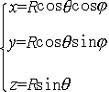 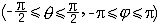 (图1)。如果把球面看成地球时,参数θ就是地球上的纬度,j就是经度。经度和纬度也叫做地球上一点的地理坐标。用平面去截球面,所得交线是圆。当平面通过球心时,在球面上截得的圆最大,称为球面上的大圆,不过球心时截得的圆称为小圆。小于半圆的弧称为劣弧。把地球表面近似地看成一个球面时,经线就是从北极到南极的半个大圆,赤道是一个大圆 ,其他纬线都是小圆(图2)。连接球面上两点的所有曲线段之中以连接这两点的大圆的劣弧为最短,称为球面上两点间的距离。因此在天空中的飞机和在大洋中的轮船,都尽可能沿大圆弧航行。球面半径为R时,球面面积为4πR2,球的体积为 (图1)。如果把球面看成地球时,参数θ就是地球上的纬度,j就是经度。经度和纬度也叫做地球上一点的地理坐标。用平面去截球面,所得交线是圆。当平面通过球心时,在球面上截得的圆最大,称为球面上的大圆,不过球心时截得的圆称为小圆。小于半圆的弧称为劣弧。把地球表面近似地看成一个球面时,经线就是从北极到南极的半个大圆,赤道是一个大圆 ,其他纬线都是小圆(图2)。连接球面上两点的所有曲线段之中以连接这两点的大圆的劣弧为最短,称为球面上两点间的距离。因此在天空中的飞机和在大洋中的轮船,都尽可能沿大圆弧航行。球面半径为R时,球面面积为4πR2,球的体积为 。 。
|

说明:补充资料仅用于学习参考,请勿用于其它任何用途。
参考词条