1) Qilian Shanmai

祁连山脉
2) Qilian Mountains
祁连山
1.
Analysis of the Spatial and Temporal Changes in Soil CO_2 Efflux and Its Related Factors from Alpine Meadow in Qilian Mountains;
祁连山高山草甸土壤CO_2通量的时空变化及其影响分析
2.
Formation conditions of gas hydrates in permafrost of the Qilian Mountains, Northwest China.;
祁连山多年冻土区天然气水合物的形成条件
3.
Design on Evaluate Indicator System of Eco-environment Quality in Qilian Mountains;
祁连山区生态环境质量评价指标体系的构建
3) Qilian Mountain
祁连山
1.
Ecological Resilience of Qilian Mountain Nature Reserve.;
祁连山自然保护区生态承载力分析与评价
2.
Beneficial Prediction and Assessment of Cloud and Air Water Resource Exploitation over the Qilian Mountain;
祁连山空中云水资源开发利用效益预测与评估
3.
Temporal heterogeneity of soil moisture under different vegetation types in Qilian Mountain;
祁连山浅山区不同植被类型土壤水分时间异质性
4) North Qilian mountains
北祁连山
1.
SHRIMP U-Pb Geochronological Research on Detrital Zircons from the Beidahe Complex-Group in the Western Segment of the North Qilian Mountains, Northwest China;
北祁连山西段北大河岩群碎屑锆石SHRIMP U-Pb年代学研究
2.
Reconstruction of protoliths of metamorphic rocks and tectonic setting of the Haiyuan Group in the Haiyuan in the eastern segment of the North Qilian Mountains, China.;
北祁连山东段海原一带海原群变质岩原岩恢复及其构造背景
3.
Chronology and Geological Significance of Chelugou Dacite Porphyry in North Qilian Mountains;
北祁连山车路沟英安斑岩的年代学及地质意义
5) North Qilian Mountain
北祁连山
1.
Geology and Geochemistry of Volcanic Rocks of the Early Ordovician Yingou Group in the Western Part of North Qilian Mountain and Their Tectonic Setting;
北祁连山西段早奥陶世阴沟群火山岩的构造背景
2.
Recent discovered Hanshan gold deposit is a structure-controlled altered rock type related with intrusive rocks in North Qilian Mountain.
寒山大型金矿是近年来在北祁连山西段发现的与基性火山岩有关的构造蚀变岩型金矿。
3.
In the past several years,more than a dozen of gold deposits and gold occurrences,such as Hanshan,Yingzuishan,Changma,Hongkouzi and Zhulong,have been discovered in the western part of North Qilian Mountain.
北祁连山西段金矿床以剪切带型为主 ,控矿的主导因素是剪切构造和成矿流体。
6) the Qilian Mountain
祁连山
1.
Study on the Assessing Model of Stability of the Mountainous Ecosystem in the Qilian Mountain;
祁连山山地生态系统稳定性评估模型
2.
Characteristics of Soils and Land Suitability in the Western Segments of the Qilian Mountain and the Hexi Corridor;
祁连山及河西走廊西段土壤和土地适宜性特征
3.
By analyzing spectrum characteristics of snow,clouds and different land covers in the Qilian Mountain region based on MODIS data from July 2003 to March 2005,a new method for snow discrimination is presented on the basis of former researches,which combined NDSI(Normalized Difference Snow Index) and band 18,band 31 of MODIS to discriminate snow from clouds,saline,ice,desert,etc.
对祁连山区积雪、云和各种下垫面进行光谱分析,利用2003年7月至2005年3月的MODIS数据资料,在前人所做研究工作的基础上提出利用归一化差值积雪指数NDSI(Normalized Difference Snow Index)和中分辨率成像光谱仪(Moderate Resolution Imagigng Spectroradiometer)的band 18和band31的结合,采用逐步逼近法去除大部分云、盐湖、冰面、沙漠、戈壁等对积雪判识的干扰,从而判识出祁连山区积雪。
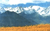
补充资料:祁连山脉
| 祁连山脉 位于中国青海省东北部与甘肃省西部边境。由多条西北-东南走向的平行山脉和宽谷组成。因位于河西走廊南侧,又名南山。西端在当金山口与阿尔金山脉相接。东端至黄河谷地,与秦岭、六盘山相连。长近1000千米。属褶皱断块山。最宽处在酒泉市与柴达木盆地之间,达300千米。自北而南,包括大雪山、托来山、托来南山、野马南山、疏勒南山、党河南山、土尔根达坂山、柴达木山和宗务隆山。山峰多海拔4000~5000米,最高峰疏勒南山的团结峰海拔5808米。海拔4000米以上的山峰终年积雪,山间谷地也在海拔3000~3500米之间。祁连山东段山势由西向东降低,包括走廊南山-冷龙岭-乌鞘岭,大通山-达坡山,青海南山-拉背山三列平行山系 。其间夹有大通河谷地、湟水谷地和青海湖盆。有冰川3306条,面积2063平方千米。祁连山区的水系呈辐射状:以哈拉湖到东经99°一带为中心,向四周辐射。在山前形成大绿洲。东部海拔2500~3300米分布有寒温带针叶林。森林资源破坏严重,野生动物减少。1987年建有祁连山国家自然保护区。矿藏丰富。狭义的祁连山,指最北的一支的走廊南山和冷龙岭。平均海拔4000米以上。主峰有冷龙岭(4843米)、祁连山(5547米)和疏勒南山(5808米)。
|
说明:补充资料仅用于学习参考,请勿用于其它任何用途。
参考词条