1) WEPP

水蚀模型WEPP
1.
Simulation of water erosion by jointly application of WEPP and GIS——Taking Xiangyanggou catchment in Yan an as an example;
基于水蚀模型WEPP和GIS的高原小流域侵蚀模拟——以延安地区向阳沟小流域为例
2.
The Application of WEPP and GIS;
水蚀模型WEPP与GIS的联合应用
2) WEPP model
WEPP模型
1.
Prediction of water erosion on purple soil slope based on WEPP model;
基于WEPP模型的紫色土坡面水蚀预报
2.
Since the development of WEPP model,many countries have tried and tested the applicability of it.
为了更全面地评价WEPP模型在我国的适用性,该文通过建立模型数据库,利用WEPP分别模拟了坡长为10、20、30和40 m的径流量和土壤侵蚀量,并用实测径流和侵蚀资料进行对比分析。
3.
This paper applies the WEPP model to simulate soil erosion and spatial variation in Sichuan hilly basin.
利用WEPP模型对川中丘陵区盐亭站5个径流小区土壤侵蚀量的预测和土壤侵蚀空间分布的模拟发现:WEPP模型对次降雨土壤侵蚀的预测,相对误差在30%以内的占总样本86%以上;对年降雨土壤侵蚀预测的误差较稳定,且相对误差均在15%以内。
3) WEPP modelling
WEPP模型
1.
Throughout the effect analyzing and comparing, and it was found that the prediction of WEPP modelling for the erosion .
WEPP模型是一种基于侵蚀过程的计算机土壤侵蚀预测模型。
4) water erosion prediction model
水蚀预报模型
1.
This paper detailedly outlined research progresses in water erosion prediction models at hillslope, watershed and region scales, and treand prediction of soil erosion at macro-scale in China.
述评了我国在坡面预报模型和流域侵蚀产沙模型、区域水土流失评价模型和全国水土流失宏观趋势预测的研究进展 ,提出了中国水蚀预报模型研究面临的挑战与任务 ,指出了我国水蚀预报模型近期研究重点。
2.
The author outlined research progress in water erosion prediction model at oversea countries,detailed reviewed empirical models,erosion models based-process,water erosion prediction model supported by GIS,rill erosion model,ephemeral erosion gully model,gully erosion model,and erosion prediction model at regional scale.
概述国外水蚀预报模型的研究进展,并详细述评了国外水蚀预报的经验模型、物理过程模型、基于地理信息系统的水蚀预报模型,细沟侵蚀模型、浅沟侵蚀模型、切沟侵蚀模型和区域侵蚀预报模型。
3.
Well-known water erosion prediction models, such as USLE, RUSLE, WEPP, EROSEM, LISEM and GeoWEPP are outlined.
除对中国学者已熟悉的CSLE,RUSLE,WEPP,EROSEM,LISEM,GeoWEPP模型进行述评外,还介绍了近年来新研发的区域侵蚀预报模型(SEMMED)、细沟侵蚀预报模型(RILLGROW)、浅沟侵蚀预报模型(EGFM)以及切沟侵蚀预报模型(GULTEM,DIMGUL,STABGUL),讨论了这些水蚀预报模型在我国推广应用面临的问题。
5) runoff and sediment yield mathmatical modelling
侵蚀水沙耦合数学模型
6) remote sensing information model of water erosion
水蚀遥感信息模型
1.
The authors firstly illustrate developments of modeling erosion by water on hillslopes, then discuss the development of empirically based model, conceptually based model, physically based model and remote sensing information model of water erosion respectively, finally compare characteristics of each type.
阐述国内外坡面土壤水蚀建模发展历程,然后分别论述经验模型、概念模型、物理模型以及水蚀遥感信息模型的发展历程,最后比较各类模型优缺点。
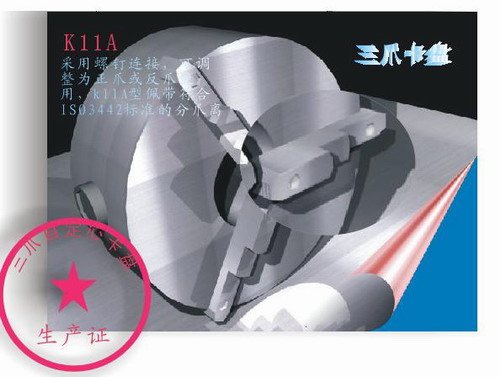
补充资料:AutoCad 教你绘制三爪卡盘模型,借用四视图来建模型
小弟写教程纯粹表达的是建模思路,供初学者参考.任何物体的建摸都需要思路,只有思路多,模型也就水到渠成.ok废话就不说了.建议使用1024X768分辨率
开始
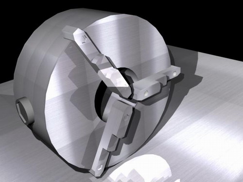
先看下最终效果
第一步,如图所示将窗口分为四个视图
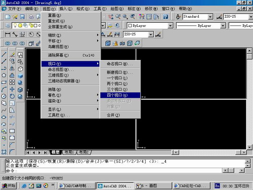
第二步,依次选择每个窗口,在分别输入各自己的视图
第三步,建立ucs重新建立世界坐标体系,捕捉三点来确定各自的ucs如图

第四步,初步大致建立基本模型.可以在主视图建立两个不同的圆,在用ext拉升,在用差集运算.如图:
第五步:关键一步,在此的我思路是.先画出卡爪的基本投影,在把他进行面域,在进行拉升高度分别是10,20,30曾t形状.如图:
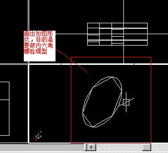
第六步:画出螺栓的初步形状.如图
第七步:利用ext拉升圆,在拉升内六边形.注意拉升六边行时方向与拉升圆的方向是相反的.
之后在利用差集运算
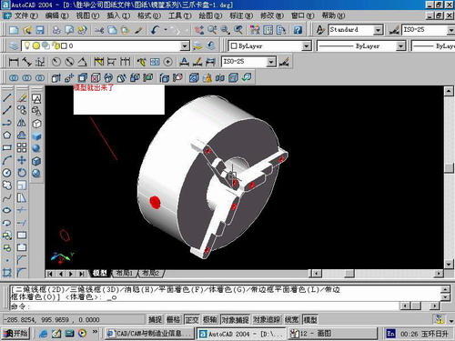
第八步:将所得内螺栓模型分别复制到卡爪上,在利用三个视图调到与卡爪的中心对称.效果如图红色的是螺栓,最后是差集
第九步:阵列
第10步.模型就完成了
来一张利用矢量处理的图片
说明:补充资料仅用于学习参考,请勿用于其它任何用途。
参考词条